SEISMIC
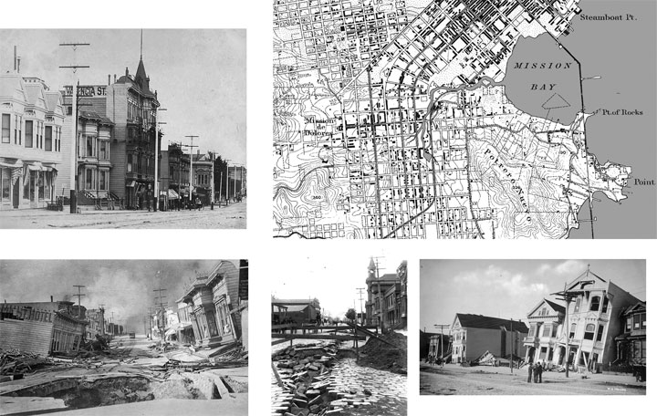
Photos of buildings in the Mission after the 1906 earthquake.
The map shows the original flow of Mission creek prior to land fill.
Earthquake Lessons Around Mission Creek, By Judy West, geologist
The 100 year anniversary of the Great 1906 Earthquake and Fire is this April 18. New books, scientific conferences and historic exhibits around the City offer something for everyone. For neighbors of Mission Creek, emergency preparedness is in order.
1906 earthquake damage is well documented in areas of soft soils like South of Market and the NE Mission, where early settlers haphazardly filled-in old marshes of the Mission Creek estuary. Fires started in crowded wood buildings from small gas leaks, which continued to start into the next day as people used gas to cook, etc. The real damage occurred from the powerful firestorm, which was impossible to stop due to broken water mains. Nearly the entire City was destroyed.
100 years later, with modern building codes and technologies, one would think our City would be safer than in 1906. But think again. Most of the existing structures in SF were built shortly after the 1906 Quake, in a frenzied effort to rebuild the City and restore business. Building construction was essentially the same wood frame, without fire insulation, although indoor plumbing was introduced.
Even modern gas lines can leak with significant shaking, and water lines are expected to fail over much of the same soft soil areas. Many of the damaged sites like the “Drunken Buildings”on SoVanNess were taken over by industrial businesses, which remain there today.
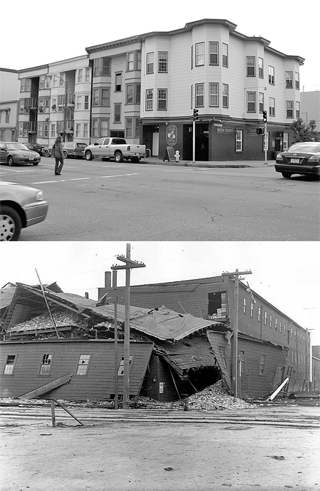
Today at the corner of 15th and Folsom
and after the quake in 1906.
The SF Fire Department is producing a historical Exposition at Pier 48 in Mission Bay, April 15-17 from 9AM to 6pm See www.1906expo.com for more details. Also check out http://1906centennial.org/
We’ve been told that in a disaster, we’ll be on our own for at least 3 - 7 days before government agencies step in. The City officials say there won't be enough firemen or policemen to go round – and that initially, we the people will be the only resource we have for rescue attempts, medical care, water, food and security. “My great-grandfather talked of his despair the day of the 1906 Quake” said Carol Horn, manager of the Hamm’s Bldg. on Bryant Street. “Fire-fighters dynamited his building on Folsom St. for a fire break as he stood by and watched”.
Instead of fretting about the unknown, our local SPCA sponsored a six week training session in March through the Neighborhood Emergency Response Team (NERT) Training Program, conducted by the SF Fire Department. They provide 20 hours of training in disaster and emergency response for no cost to groups of a minimum size. Through this program, individuals learn hands-on disaster skills that help them be members of an emergency response team. The training instructors are professional firefighters. This training is open to all people who work or live in San Francisco. For training information, go to www.sfgov.org/site/sfnert_index.asp
For more info about US Geological Society earthquake predictions, go to http://quake.wr.usgs.gov/research/seismology/wg02/
© 2011 Madrina Group. All rights reserved.

Services
Environmental Education Projects
Geological and Seismic Studies
Architectual Planning and Design
Art Projects
Educational Art
Kiosks
Mission Creek
Bikeway maps
Mosaics
Murals
323Gallery
Panel 1 - The Bay Trail
Panel 2 - Mission Creek Corridor
Panel 3 - Historic Shorelines of SF
Panel 4 - Blue Greenway
Panel 5 - Mission Bay
Panel 6 - Pier 52
Panel 7 - SF Estuary
Panel 8 - SF Watershed